![]()
Geography of Virgaard
| Mountains | Notable Sites |
| Forests | Neighbours |
![]()
The borders of the Principality extend from the Adri Varma Plateau's rift at the West, to the Principalities of Boldavia and Crownguard at the East, towards the Kingdom of Wendar at the North, and touch the Principalities of Berdghoven and Aalban at the South.
|
|
Click here for a map of Virgaard |

Virgaard is a vast domain, created in a troubled time of Glantrian History, when the Council of Princes needed the northern region of the Land to be firmly administrated by strong dominions in order to help preventing any invasion from Ethengar or attacks from Heldann.
Mountains
The Principality of Virgaard extends over the Glantrian part of the Wendarian Ranges, an old and eroded but relatively high range of mountains located north of Glantri.
Although high in altitude, the ranges are quite easy to get throught because of the many passes and canyons, as well as a huge dwarven-made road, that crosses the ranges from south to north, linking Fort Northling to Mithrandyl via Dragonsdale Pass.
This road was built in 1006 AC thanks to Princess Altaïs' personnal treasury and to the support of the Chamberlain of the Land. It has permitted the cultural, political and commercial exchanges with the Kingdom of Wendar to boost up.
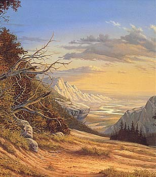
a view of the Valley of Vorstadt from the Wendarian Ranges - by Larry Elmore
There are several forested depressions and canyons within the ranges, which are mostly inhabited by foresters' colonies, or more deadly monsters. It is not uncommon to see dragons, griffons or hypogriphs flying above the mountains.
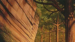
Forest of the Mithrandyl Valley - by Larry Elmore
Forests
The northern part of the Principality, just next to the border with Wendar, is composed of a chain of forested hilly valleys, crossed by the Rowena river (in the name of Princess Rowena of Virgaard).
The forests are relatively dense and the terrain is mainly rocky.
The population is more dense in these valleys, for they host the cities and villages of the Principality:
|
The Mithrandyl Valley guards the pass to Wendar, with Fort Dragonsdale and the Tower of Mithrandyl, siege of the Principality. |
|
The Valley of Elversult hosts the major town of the Principality, on the bank of lake Altaïs. |
|
The Valley of Wozlan is famous for its Labyrinth of Death, a yearly adventuring contest organized by Lord Sukumvit, Baron of Fang. |
|
The Lawensa Depression is the shelter of a secret elven sanctuary, concealing the sister Tree of Life of Clan Fëadil in Alfheim. |
Notables Sites
|
Mount Amador is the highest mountain of the Wendarian Ranges (4 400m). It used to host the secret lair of Amanth, an evil red dragon queen . In 1010 AC, Prince Vaëlmir decided to get rid of the permanent threat of a red dragon clan in the mere centre of the Principality and raided Amanth's lair. He killed the mighty dragon and discovered a huge complex of caves and mazzes inside the mountain. "Amanthyr" is now a secret base for the Virgaardian flying vessels fleet. |
|
The Adri-Varma Plateau |
The Lawensa Depression |
The Dragonsdale Pass |
Harald's Lake |
|
Ergoth is a draconic sanctuary, dedicated to the Great One, Immortal Ruler of all Dragons. The sanctuary is located above a deep canyon, in the center of a huge dragon-shape rock. |
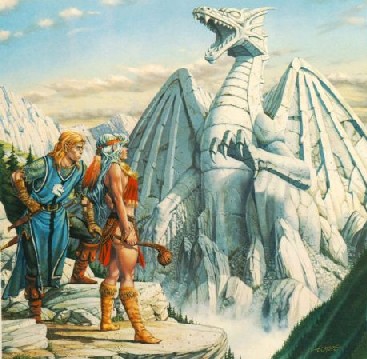
Stone Dragon of Ergoth Sanctuary - by Larry Elmore
![]()
Neighbours
Principality of Aalban |
Principality of Berghdoven |
Principality of Boldavia |
Principality of Crowguard |
Kingdom of Wendar |
![]()